Uphill
124m

Length
3km
Duration
1h
Elev gain
124m
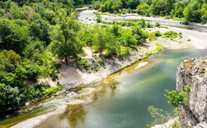
Leaving from Sanilhac, this walk makes a loop in the woods and runs along a small stream. Please note that the path of this course tends to be very wild, it is possible that the path is covered by flora.

Already more than 200,000 users!
Uphill
124m
Highest point
566m
Downhill
124m
Lowest point
468m
Route type
Loop
Download the map on your smartphone to save battery and rest assured to always keep access to the route, even without signal.
Includes IGN France and Swisstopo.
I indicate whether dogs are allowed or prohibited on this trail
All year
0 ratings
Also enjoy:

Already more than 200,000 users!