Uphill
118m

Length
7km
Duration
2h
Elev gain
118m
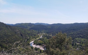
Walk from the charming village of Mialet. The route loops around the surrounding villages and hamlets, places marked by the wars of religion under the reign of Louis XIV. Note that the route follows the road several times and runs along the Gardon de Mialet.

Already more than 200,000 users!
Uphill
118m
Highest point
225m
Downhill
118m
Lowest point
144m
Route type
Loop
Download the map on your smartphone to save battery and rest assured to always keep access to the route, even without signal.
Includes IGN France and Swisstopo.
I indicate whether dogs are allowed or prohibited on this trail
All year
0 ratings
Also enjoy:

Already more than 200,000 users!