Uphill
616m
Length
10km
Duration
4h30min
Elev gain
616m
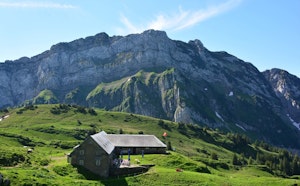
Departing from Rieden, this hike crosses pretty landscapes, passes through Bachmannsberg then continues to Bäruus before reaching the Tanzbodenhütte refuge, located at an altitude of 1,443 metres. Then it descends through the Bächenwald forest and the Zinggenwald forest until it reaches the starting point, Rieden.

Already more than 200,000 users!
Uphill
616m
Highest point
1440m
Downhill
616m
Lowest point
855m
Route type
Loop
Download the map on your smartphone to save battery and rest assured to always keep access to the route, even without signal.
Includes IGN France and Swisstopo.
I indicate whether dogs are allowed or prohibited on this trail
Can be difficult in Winter
0 ratings
Also enjoy:

Already more than 200,000 users!