Uphill
768m
France > Provence-Alpes-Côte d'Azur > Alpes-Maritimes > Préalpes d'Azur Regional Natural Park
Length
15km
Duration
6h
Elev gain
768m
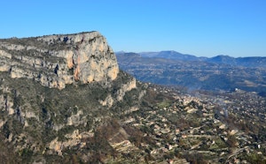
Away from Baous Saint-Jeannet and Gaude, the Mouton d'Anou consists of a beautiful promontory between sea and mountains.

Already more than 200,000 users!
Uphill
768m
Highest point
1075m
Downhill
768m
Lowest point
436m
Route type
Loop
Download the map on your smartphone to save battery and rest assured to always keep access to the route, even without signal.
Includes IGN France and Swisstopo.
Parking René Veyssi, next to the village of Saint-Jeannet. Arrive early to have spaces in high season.
Lignes d'Azur bus stop nearby.
I indicate whether dogs are allowed or prohibited on this trail
All year
0 ratings
Also enjoy:

Already more than 200,000 users!