Uphill
1073m

France > Auvergne-Rhône-Alpes > Isère > Chartreuse Regional Natural Park
Length
20km
Duration
8h30min
Elev gain
1073m
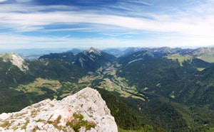
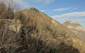
From the start, the path leaves Sappey-en-Chartreuse and goes into the forest on the side of the majestic Chamechaude, with a relatively steep slope. The Col de la Porte then offers a respite, before starting a new climb leading just below the Pinéa (1,771 m) and the Charmant Som (1,867 m), all this by taking a ridge line at the points of extraordinary view.
Finally, the trail descend towards Saint-Pierre-en-Chartreuse to complete this second day of walking.

Already more than 200,000 users!
Uphill
1073m
Highest point
1731m
Downhill
1202m
Lowest point
792m
Route type
One way
Download the map on your smartphone to save battery and rest assured to always keep access to the route, even without signal.
Includes IGN France and Swisstopo.
Saint-Pierre-en-Chartreuse has several gîtes and restaurants for the evening.
I indicate whether dogs are allowed or prohibited on this trail
From May to October
3 ratings
Also enjoy:

Already more than 200,000 users!